
Online Quiz
Stratigraphy & Historical Geology
Important concepts
Stratigraphy: the study of stratified rocks, their nature, occurrence, classification, & relationships to each other
Historical Geology: the study of the history of the earth
Historical Geology includes stratigraphy
History of The Relative Geologic Time scale
How geologic mapping in Europe led to the relative time scale
1. by the principle of superposition
2. by the principle of fossil correlation
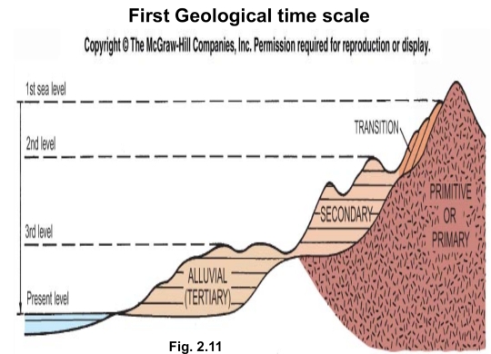
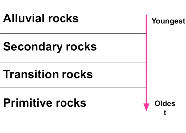
Based on the Neptunism theory
Present level → Alluvial rocks or Tertiary
3rd level → Secondary rocks
2nd level → Transition rocks
1st level →Primitive or Primary rocks
After publication of Smith’s & Cuvier’s geological maps in the 1800s, the case was:
Wernerian Chronology continued to used
استمر استخدام التسلسل الزمني
Local names of strata became more numerous
اصبحت الاسماء المحلية للطبقات اكثر عددا
Naming of distinctive rock bodies was a natural by product of mining & mapping
كانت تسمية الاجسام الصخرية المميزة امرا طبيعيا بالتعدين والخرائط
Names developed as shorthand & reflected geographic localities or rock types
تم تطوير الاسماء بطريقة مختصرة وتعكس هذه الاسماء المواقع الجغرافية وانواع الصخور
these names was extended more widely as a result of the lateral continuity
تم تعميم هذه الاسماء على نطاق اوسع
At the same time fossils were being collected & widely separated strata were correlated
بنفس الوقت جُمعت الاحافير، وربُط طبقات منفصلة بالمقارنة
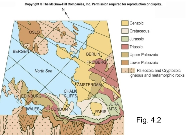
The result Geological map of all western Europe gradually developed
النتيجة: تطورت الخريطة الجيولوجية لاوروبا الغربية تدريجيا
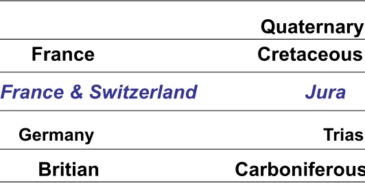
Jura
A group of secondary strata (named for the Jura mountains of France & Switzerland)
When superposition principle applied, the Jura were found to overlie another group:
1. Trias in Germany
2. Cretaceous in France
3. Carboniferous coal-bearing strata, Britian
in 1829 the name Quaternary was proposed to include the young deposits
This scheme displaced the older Wernerian scheme
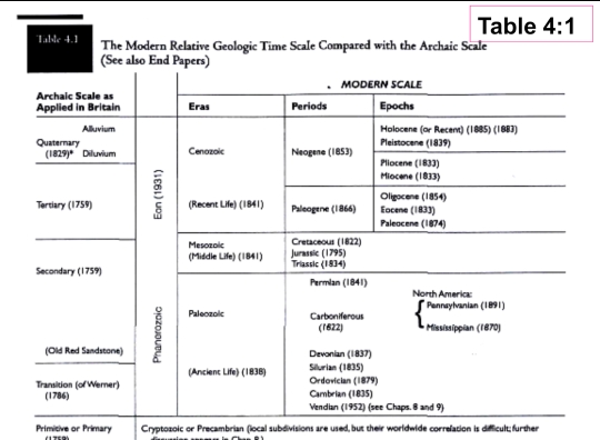
Modern Relative Time Scale
In 1835 Sedgwick & Murchison named
1. Cambrian (roman name of Wales)
2. Silurian (for an ancient welsh tribe)
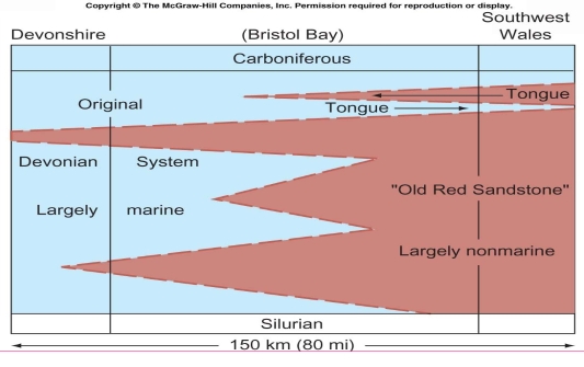
3. Devonian: Based on the correlations & fossils content they defined the relative age of Devonshire strata (between Silurian & Carboniferous)
Sedgwick proposed a large division which include smaller subdivisions (such as Paleozoic Era)
Mesozoic & Cenozoic Eras named Based on relative percentages of living species
The Permian Period was named next
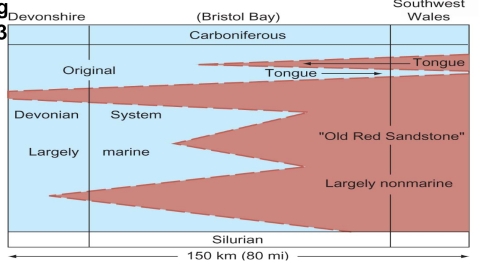
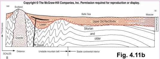
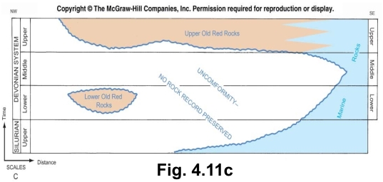
Devonian facies of Devonshire
Inter-tonguing of marine & non-marine deposits proved the Devonian age of the Old Red Sandstone
These facies also proved that different environments of deposition existd
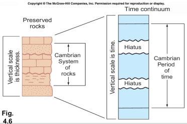
abstract geological time & rock record
There is a clear distinctions between the abstract geological time & rock record by: time is continuous, but rock record is riddled with unconformities of varying magnitude
So what we known of history must be gleaned from the imperfect rock record
If elsewhere a more complete sequence of Cambrian rocks were found with fewer & smaller unconformities & more fossils, it might provide a better world standard of reference than does that of Wales, Thus, what we have are time & rock divisions
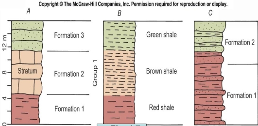
The Formation
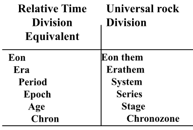
Important stratigraphical terms
Arranged from the largest to smallest
Group: rock unit consisting of more than one formations that are next to each other in a succession & related to each other
Formation: distinctive series of strata that originated through same formative processes, is the most basic local units of stratigrphy
Member: a part of a formation
Bed or strata: sedimentary rocks layer that is marked off above & bellow by surfaces that can be seen & made up of material that is the same in all parts
Lamina: thin layer (<10mm) in sedimentary, separated from material above & bellow it
Formation must be
distinctive in appearance in order to be easily recognizable
named for type locality where they normally displayed in well-exposed type section
Characteristics chosen to define a formation include one or more of the following (Lithology)
1. Composition of mineral grains
2. Color
3. Textural properties (Ex. size of grain)
4. Thickness & geometry of stratification
5. Character of any organic remains
6. Outcrop character
– Formation include > one stratum
– Group contains > one Formations
Problems arise when a new formation defined
1. The name
2. The type section
3. Designation of lower & upper limits
4. formations might vary in sediment type, or lithology, laterally or vertically, depending on deposit environments
formations might vary
The stratigraphic divisions being named in Europe were universally present & of the same age worldwide
In another word as long the geologist found the same fossils in different & far stratified rocks they assigned the same age for both of them (Ex. the Cambrian strata in Wales)
This mean that Geologist thought that any named formation should laterally extend without change
This principle was the cornerstone of Werner’s time scale
In 1789 French writings show that: similarity of fossils in similar sedimentary rocks might reflect environmental factors rather than strict age equivalence
the sedimentary products of each environment have aunique characteristics, even though they accumulate at the same time & grade gradually into one another
The result in other words is: formations might vary in sediment type, or lithology, laterally as well as vertically
The last result was supported by sedgwick & Murchison in the 1830s
sedgwick & Murchison determined that the dominantly non- marine deposits of the Old Red sandstone of Wales are Synchronous with marine Devonian deposits farther south based on the intertonguing interpretation
inter-tonguing: 2 different lithologies can grade laterally into one another in complex manner
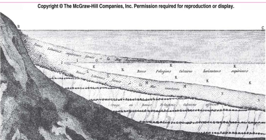
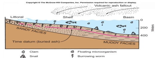
Depositional Environment & Sedimentary Facies The lateral changes of lithology & fossils contents brings the sedimentary facies concept after a well-exposed example of lateral changes of both lithology & fossils was described in 1883 in Switzerland
Sedimentary Facies
characters of a sedimentary rock, especially those that indicate the deposition environment
– Facies identified by their dominant lithology
– the study of sediments & organisms in modern environments provides important clues for understanding ancient facies, Because the facies concept relates sediments to their depositional environments
The sedimentary environment
The conditions under sediment deposited
– affect texture, composition, & structure of sediments
– for example
1. The depth & temperature of the water
2. The strength & direction of the currents

Ex. sand & mud facies
Coarser sediments occur in strongly agitated, near shore environments.
Bottom-dwelling organisms in the different environments differ considerably.
The upper surface of the diagram is a map of modern bottom-sediment types showing lateral variations only at a moment in time.
Sides are cross sections showing facies relationships through time.

Straight, sharp, symmetrical ripple crests are typical of those formed by waves in shallow water
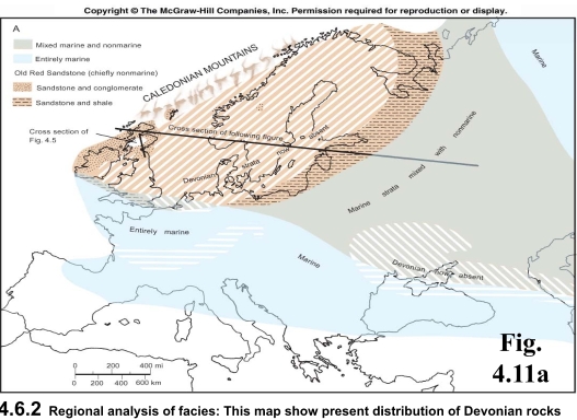
This is reflected by:
1. More & greater unconformities in W
2. Coarse & thick non-marine sediments in W
3. Finer & more marine deposits in E
4. Erosion of the Caledonian Mountains shed immense volumes of coarse debris eastward, greatest thicknesses are nearest mountains
uplift of the mountains was spasmodic, for a major unconformity divides the Old Red Sandstone at the left & of the section
Preservation of large volumes of most strata requires one or both of following conditions
Subsidence of earth crust during deposition
a rise of sea level
2 types of facies patterns
1. Transgressive facies pattern
2. Regressive facies pattern
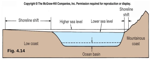
Transgression
the advance of the sea over the land
– reflect shrinkage of land area
– preceded by an erosional unconformity
– show landward shift of facies via time
– tend to become finer upward at any one geographic locality
caused a continuous shift of environments & their sedimentary & biological products landward

Regression
retreat of the sea from land area, it has the opposite effects than of Transgression
– reflect enlargement of land area
– followed by an erosional unconformity
– show seaward shift of facies through time
– tend to become coarser upward at any locality
results from
1. relative fall of sea level
2. rise of land level


Walther’s law
Vertical progression of facies will be the same as corresponding lateral facies changes
result of this fact Environments shifts position through geologic time & the respective sedimentary facies of adjacent environments succeed one another in vertical sequences
So.
1. in TFP, just as the sequence becomes finer upward, the finer facies also spreads laterally in the direction of transgression
2. just as a regressive sequence becomes coarser upward, coarser facies also spreads laterally in the direction of regression
Local Versus Worldwide
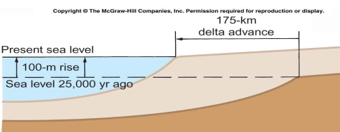
Sea level changes may result from:
1. fluctuating continental glaciation
2. large-scale warping of deep ocean basins
– such as Netherlands & California
Rapid Sedimentation
Very rapid sedimentation result from:
1. uplift of a distant inland area
2. climatic change that accelerates erosion
The above factors cause
1. local seaward retreat of shoreline independent of structural warping of crust
2. worldwide changes of sea level
Biostratigraphic Concepts
Fossil zone
An interval of strata characterized by a distinctive index fossil
Close attention must be paid to overlapping stratigraphic ranges of index fossils
Both range & abundance of a single species vary from place to place
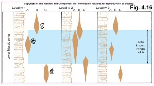
Environmental changes may have been more rapid than evolutionary ones
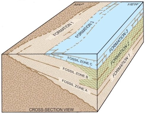
Lithologic formation boundaries need not have any relationship to the biostratigraphic boundaries of fossil zones
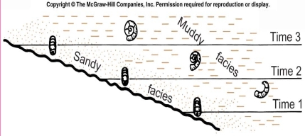
Cephalopods are swimming forms found in the muddy facies. They evolved rapidly, therefore, their species are admirable index fossils for times 1,2 & 3
Facies fossils
fossil type which restricted to lithology
Bottom dwelling organisms tend to be restricted to one facies, so they aren’t recommended as index fossils for facies correlation
Many facies-dependent fossils are useful environmental indicators for the sediments in which they occur
Formation 3 is synchronous everywhere, 1 & 2 vary in age due to lateral facies changes
Un conformities
Un conformities
Traced & mapped to established their physical continuity
Studied from the standpoint of age such as unconformity surface varies in age from place to place
The total time interval represented by the discontinuity may vary greatly
An unconformity may even disappear laterally into a continuous, unbroken, or conformable sequence of strata, this means unconformities show lateral & vertical differences as important as of rock units
Types of Unconformities
Angular unconformity: there is angle of discordance between older& younger strata
– This type shows that severe deformation occurred before unconformity was buried
Disconformity: no discordance between strata below & above discontinuity surface
Nonconformity: when the underlying rocks are igneous or metamorphic

Unconformity-Bounded Sequences
new way of studying stratigraphic record & formed additional type of stratigraphic division
– suggested by Sloss In the 1950
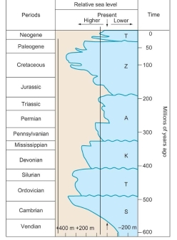
From the unconformities a worldwide sea level fluctuation curve for the past 600 m.ys has been inferred
Additional Relative Time Scales
Index fossils aren’t only things that provide worldwide, synchronous punctuations of the rock record with potential for correlating & subdividing that record
There are some alternatives that provides relative-age scales with special applications:
1.The sequence unconformities which reflect the global sea- level changes
2. Worldwide magnetic polarity reversals
3. Chemical analyses for rare or trace elements & isotopes in sedimentary rocks also provide potential for relative geochemical time scales
