
Earth’s Processes
Earth’s Processes
External Processes: Occur at or near Earth’s surface, Weathering, Masswasting, & Erosion
Internal processes: derive their energy from Earth’s interior, Mountain Building & Volcanic Activity
Mass Wasting
is the downslope movement of rock & soil due to gravity
Controls & triggers of mass wasting:
1. Water: Reduces the internal resistance of materials & adds weight to a slope
2. Oversteepening of slopes
3. Removal of vegetation: Root systems bind soil & regolith together
4. Earthquakes & aftershocks: dislodge large volumes of rock & unconsolidated material
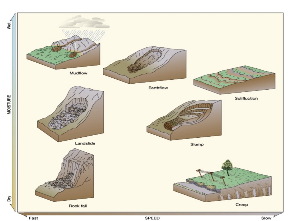
Mass Wasting Types
Slide material contact with the surface
– It can preserve its form or deformed
– include
1. Rock slides or land slides translation movement along a planer surface
2. Slump rotational along concave surface
Fall free fall, looses contact with surface
Flow movement of unconsolated material saturated with H₂O with other behaving in a plastic to liquid manner, contact with surface
– Individual particles get rearranged
– include
1. Dibri flow (or solifluction flow)
2. Earth flow
3. Mud flow
Water Cycle
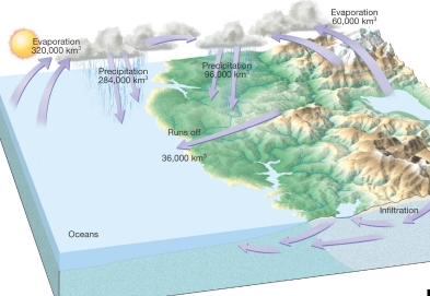
Processes in the water cycle
Precipitation Water returns to earth
Evaporation transfer from liquid to solid
Infiltration water absorption by Rock & soil
Runoff Water returns to water bodies
Evapotranspiration Evaporation by plants
Sublimation: transfer from the gaseous state of the solid or liquid
Condinsation forms clouds
In hydrologic cycle output = input, rate of Evaporation = rate of preciptation
Running Water
Stream flow
Stream water running in a channel
The ability of a stream to erode & transport materials is determined by velocity
Factors that determine velocity
1. Gradient, or slope: vertical drop of a stream over a specified horizontal distance
2. Discharge: The volume of water moving past a given point in a certain amount of time
2. Channel characteristics:
– Shape: V-shaped (up) & Semicircle (down)
– size: directly proporational to velocity
– roughness: inversaly proporational to velocity
Cross-sectional, view of stream
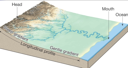
headwaters (source)
Viewed from the head, to mouth of a stream
Up stream (Head)
law velocity, law discharge, small size, steep gradient, V-shaped, & Rough
Down stream (Mouth)
high velocity, high discharge, large size, gentle gradient, semicircle, smooth curve
Drainage basins & pattern
Drainages
Drainage Basins: Drainage networks, land area that contributes water to the stream Drainage pattern: interconnected network
Drainage Basins include Tributary, River, Delta, & Ocean
divide: Imaginary line separating one basin from another


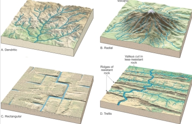
Dendritic, Radial, Rectangular, & Trellis
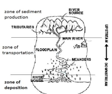
River systems
River systems
divided in 3 zones based on the dominent processes operating within them:
1. Zone of Sediment Production
2. Zone of Sediment Transport
3. Zone of Sediment Deposition
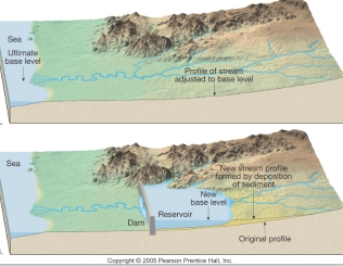
Base Level
Base level: is the lowest point to which a stream can erode
Two general types of base level
1. Ultimate (sea level)
2. Local (temporary)
There are 2 forms of river erosion
1. Down cutting esosion
2. Lateral esosion
Changing conditions causes readjustment of stream activities
1. Raising base level causes deposition (decreasing in velocity & Gradient)
2. Lowering base level causes erosion (increasing in velocity & Gradient)
The Work of Streams
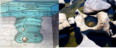
Stream erosion
Lifting loosely consolidated particles
Abrasion & Dissolution
Potholes formed when a strong current moves large paticles
Transport of sediment by streams
stream’s load Transported material
Types of load
1. Dissolved load (in solution) 115-120 ppm
2. Suspended load (silt & clay)
3. Bed load (down cutting of stream)
Competence the max. particle size stream can transport, Determined by the stream’s velocity
Capacity the max. load a stream can transport per time, increases with discharge
Deposition of sediment by a stream
Caused by a decrease in velocity
– Competence is reduced
– Sediment begins to drop out,each particle size has a critical settling velocity
– Solid particle of various size separated(sorting)
Stream sediments (alluvium) well sorted
Stream channels
Bedrock channels found in headwaters, steep gradient, V-shaped, rivers cut into bedrock. Waterfalls & pot holes are usually seen
Alluvial channels composed of loosely consolidated sediment (alluvium)
2 types of Alluvial channels
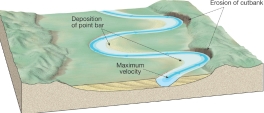
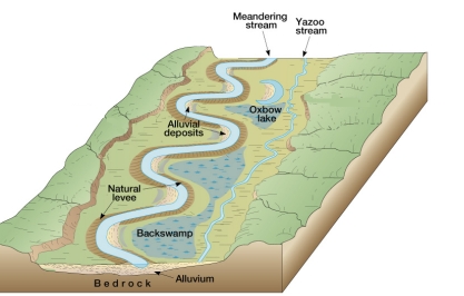
Meandering: move in sweeping bends, found in downstream, becomes mendering because if lateral erosion
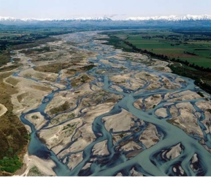
Braided consist of network of converging & diverging channels (load consists of coarse material & the stream has high discharge)
Forms of deposition of sediments by streams
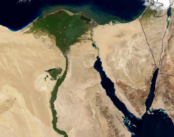
Delta Body of sediment where a stream enters a lake or the ocean
Natural leveesForm parallel to the stream channel by successive floods over many years
Floodplain deposits
Results from a sudden decrease in velocity
Natural levees
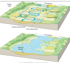
Formation of Back swamps
Yazoo tributaries
Stream Valleys
Common landforms on Earth’s surface
Two general types of stream valleys
1. Narrow valleys
– V-shaped
– Downcutting toward base level
– Features often include rapids & waterfalls
2. Wide valleys
– Stream is near base level
– Downward erosion is less dominant
– Stream energy is directed from side to side
– forming a floodplain
Features of wide valleys often include
– Floodplains
– Meanders
– Cut banks & point bars
– Cutoffs & oxbow lakes
Floods & Flood Control
Floods are the most destructive hazard
Causes of flooding
Result from naturally occurring & human induced factors
Causes include
– heavy rains
– rapid snow melt
– dam failure
– topography, & surface conditions
Flood control
1. Engineering efforts: Artificial levees, Flood control dams, & Channelization
2. floodplain management Nonstructural approach
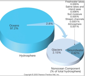
Water Beneath the Surface
freshwater
Largest freshwater reservoir for humans
Geological roles
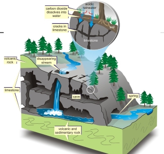
1. erosional agent, dissolving by groundwater produces: Sinkholes, & Caverns
2. An equalizer of stream flow
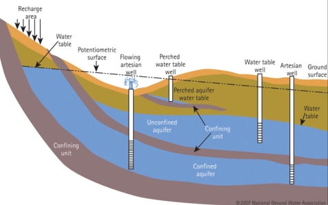
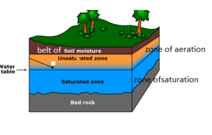
Distribution of groundwater
Belt of soil moisture
– Zone of aeration
– Unsaturated zone
– Pore spaces of material are filled with air
Zone of saturation
– All pore spaces of material filled with H₂O
– Water within the pores is groundwater
Water table upper limit of zone of saturation


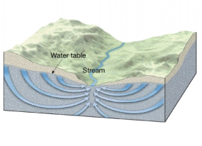
Movement of groundwater
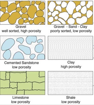
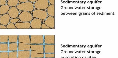
Porosity Percentage of pore spaces to the total volume of the rock.
– determines how much groundwater can be stored
Permeability Ability to transmit water via connected pore spaces
– Pores must be connected & large enough to allow movement
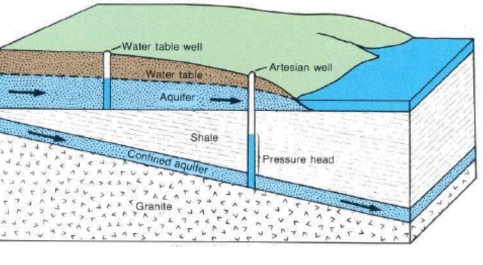
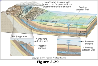
Aquitard impermeable layer of material (clay)
Aquifer permeable layer of material (sand & gravel)
confined aquifer confined between 2 aquitard
unconfined aquifer water table forms the upper boundary

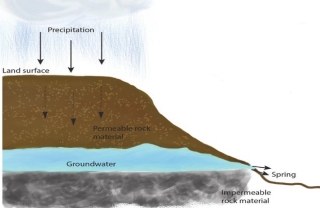
Springs
Whenever the water table intersects surface
Hot springs
– Water 6 – 9ºC warmer than air temperature
– depth increase of temperature by 2°C/100m
– Heated by cooling of igneous rock
Geysers
– Intermittent hot springs in which columns of water are ejected with great force at various intervals
– Water turns to steam & erupts
– occur where extensive underground chambers exist within hot igneous rocks
– At the bottom of the chamber, the water is under great pressure preventing water from boiling at 100°C
Wells
Well a hole bored in the zone of saturation to remove groundwater
Artesian Wells Water in the well rises higher than the initial groundwater level
– Artesian wells act as “natural pipelines” moving water from remote areas of recharge great distances to the points of discharge
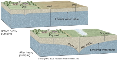
Pumping cause a drawdown (lowering) & a cone of depression in the water table
Environmental problems associated with groundwater
– Treating it as a nonrenewable resource
– Land subsidence caused by its withdrawal
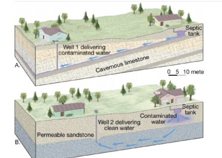
Contamination
Geologic work of groundwater
dissolves rock
Groundwater if often mildly acidic
Contains weak carbonic acid
CaCO₃ + H₂CO₃ → Ca⁺ + 2HCO₃-
Calcite → bicarbonate ion carried away in solution
Dissolves calcite in limestone
Caverns Formed by dissolving rock beneath Earth’s surface, in the zone of saturation
– Composed of dripstone
– Calcite deposited as dripping H₂O evaporates
Features found within caverns
1. Stalactites hanging from the ceiling
2. Stalagmites (dripstones) growing upward from the floor
Karst topography
Formed by dissolving rocks at or near surface
Area lacks good surface drainage
Common features
1. Sinkholes Surface depressions, form by dissolving bedrock & cavern collapse
2. Caves & caverns
Important terms
Groundwater is the largest reservoir of fresh water that is readily available to human.
Zone of aeration underground area above water table, is not fully saturated with water
Zone of saturation underground area below the water table in which the pore spaces are fully saturated with water
Water table surface that separates zone of aeration, from underlying zone of saturation
Porosity the proportion of open spaces (or pores) in sediment or rock, expressed as the percent of voids to the total rock volume
Aquifer a permeable layer of sediment or rock from which water can be obtained
spring is a naturally occurring intersection of the water table with the surface of the ground from which water flows spontaneously
A well is an opening bored down into the zone of saturation and into a confined aquifer
Overpumping resulting in
– cone of depression around the pumping well
– intrusion of salt water into freshwater well
– land subsidence
– causing damage to an aquifer resulting in such a significant water level decline
Permeability Ability to transmit water via connected pore spaces
Porosity Percentage of pore spaces to the total volume of the rock.
Drainage basin land area that contributes water to a stream
Divide imaginary line which separates drainage basins
Gradient the slope of stream channel expressed as the vertical drop of a stream over a specified distance
Discharge the volume of water flowing past a certain point in a given unit of time
base level is a lower limit to how deep a stream can erode
Meandering river generally move in a sweeping bends
Cutoff the new & shorter channel segment of meandering river, is for the outer edge of a meander, because of its shape called Oxbow
Delta may form where a river deposits sediments in another water body at its mouth
Natural levees result from sediment deposited along the margins of a stream channel by many flooding events
streams transport load of sediments in :
1. solution (dissolved particles)
2. suspension
3. along the bottom of the channel (Bed load)
The End
