
Chapter 5 : Plate Tectonics
Part1 : Plate Tectonics Theory
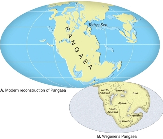
Continental Drift
hypothesis by Alfred Wegener, 1915
The hypothesis: Supercontinent began breaking apart about 200 My ago
– Continents drifted to present positions
– Supercontinent called Pangaea
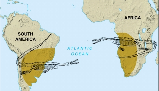
Evidence used in support of continental drift hypothesis
Fit of the continents, Fit of:
– the shore lines
– continental shelves edges at 900m depth
Fossil Distribution of fossils like Mesosaurus found in black shales of Permian age
Rock type & structural similarities
Matching mountain ranges
Paleoclimatic evidence
– Paleozoic 300Ma, ice sheets covered of SH, & India, & Now these are tropical & subtropical
– in NH large tropical swamps existed that became major coal fields of eastern USA, Europe, & Siberia now

The Great Debate
Objections to the hypothesis
– Lack of a mechanism for moving continents
– Strong opposition to the hypothesis
Continental drift & the scientific method
– Wegener incorrectly suggested that continents broke through the ocean crust, much like ice breakers cut through ice
– Wegener’s hypothesis was correct in principle, but contained incorrect details
A few scientists considered Wegener’s ideas plausible & continued the search
Plate Tectonics Theory PTT
All the following led to PTT, Oceanographic exploration after WW2, discovered:
Global oceanic ridge systems
Dredging in the seafloor didn’t bring up oceanic crust older than 180Ma
Earthquake studies revealed tectonic activity beneath deep-ocean trenches
Sediment accumulations in the deep-ocean basins were found to be thin
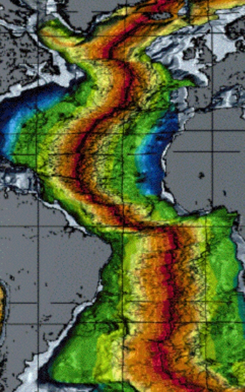
the youngest in red & orange, yellow, green, & older, & The blue rocks date to the Jurassic 150 -200Ma when Atlantic started to grow
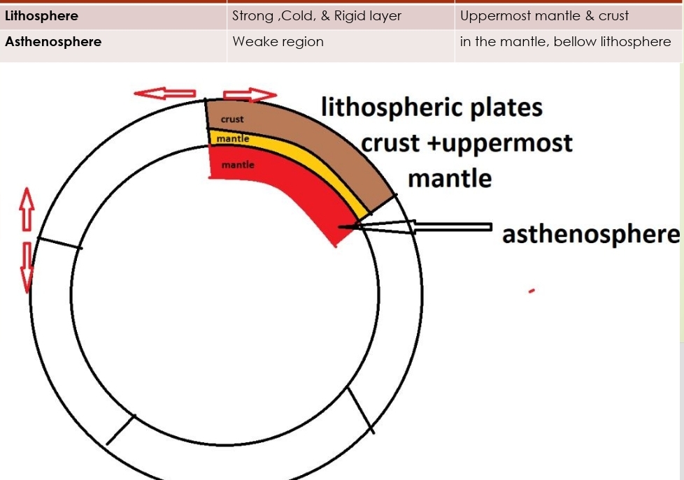
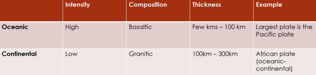
there are 7 major lithospheric plates
Plates motion & changing in shape & size
Some plates include continent + seafloor
Plates move at a rate 5cm/yr
Part2: Plate boundaries
Plate boundaries
Interactions among individual plates occur along their boundaries
Types of plate boundaries
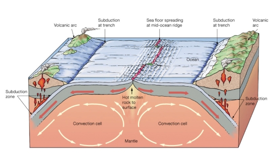
Divergent: constructive margins
Convergent: destructive margins
Transform fault: conservative margins
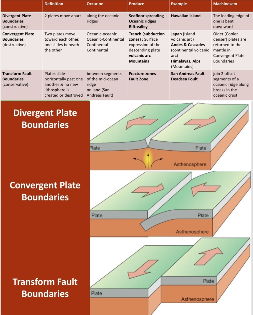
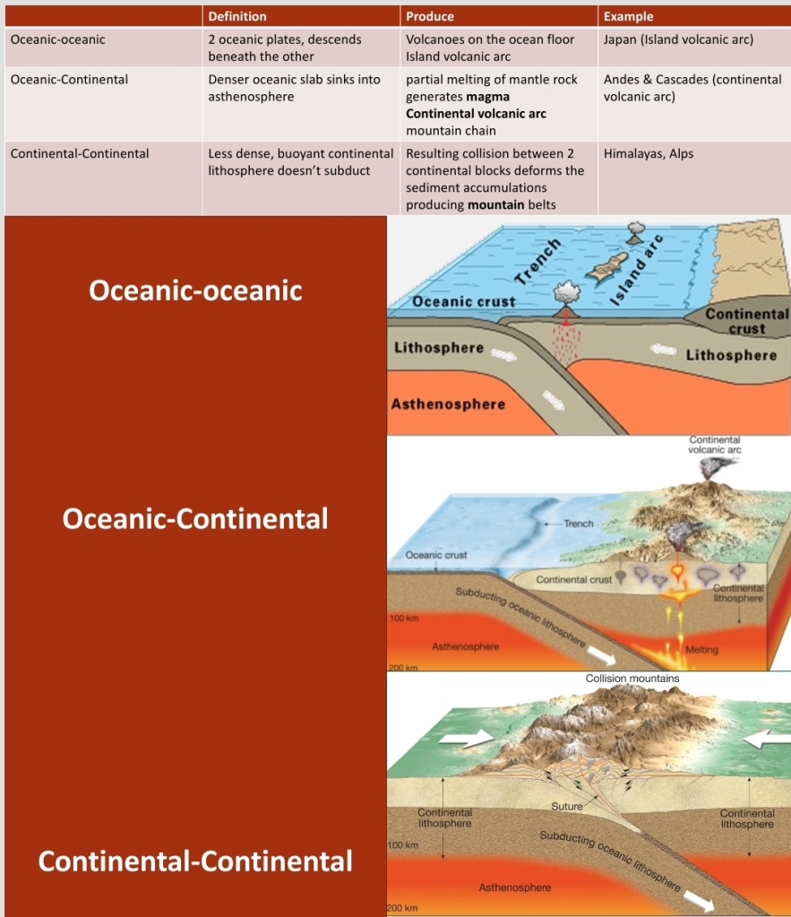
subducting plate: The plate that slides, oldest, cooler, denser
over riding plate: younger, less dense
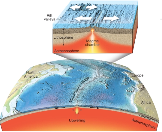
– Length 70,000km, 20% of earth surface
– Width 1000 – 4000kms
– Crest of ridges 2-3 km above seafloor
rift-valley: deep down-faulted structure along the axis of some ridge segments
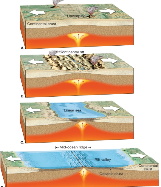
Continental rifting
splits landmasses into 2 or more smaller segments along a continental rift
Produced by extensional forces on plates
such as East African rift valleys
Ridge system & ocean basin formed if
1. Upwarping of the crust associated with mantle upwelling
2. stretching lithosphere breaks crustal rocks produced continental rift
3. Rift valley lengthens & deepens forming Linear sea
Part3 : TESTING THE PLATE TECTONICS MODEL
Evidence from ocean drilling
Age of deepest sediments seafloor spreading produced by drilling ocean-floor sediment
Thickness of ocean-floor sediments verifies seafloor spreading
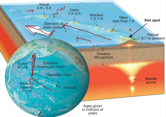
Hot spots & mantle plumes
Hot spot area of volcanism, high heat flow, & crustal uplift
Caused by rising plumes of mantle material
Mantle plumes
– Upwelling of hot rock
– Some originate at great depth
– perhaps at the mantle-core boundary
– As hot plume ascends via mantle confining P decreases causing partial melting
– This activity is seen as hot spot on surface
As Pacific plate moves over hot spot a chain of volcanic structures is built
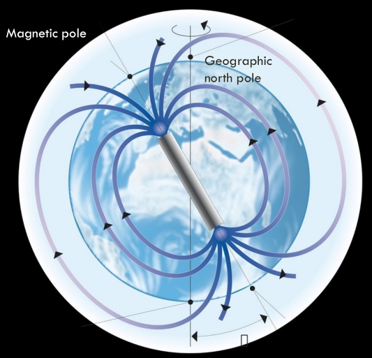
Paleomagnetism
Earth has a magnetic field similar to that produced by a simple bar magnet, & AFFECTS ALL MAGNETIC OBJECTS ON EARTH
Most Fe-bearing minerals are:
– magnetic
– gain magnetization below Curie point T
– align themselves in the direction of the existing magnetic lines of force
Rocks that formed millions of years ago contain a “record” of the direction of the magnetic poles at the time of their formation (fossil magnetism)
Apparent polar wandering
– Lava flows of different ages indicated several different paleomagnetic poles positions within the same continent
– Polar wandering curves are more readily explained by the theory of plate tectonics
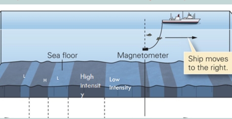
Magnetic surveys were also done in the ocean floor using a magnetometer
magnetometer instrument used to measure magnetic intensity
The surveys showed high & low intensity magnetic stripes within the ocean floor which are symmetrical along the opposite side of the ridges
When rocks exhibit the same magnetism as the present magnetic field, they are said to possess normal polarity. & Rocks with the opposite magnetism are said to have reversed polarity, Dates when the polarity of Earth’s magnetism changed were determined from lava flows
Earth’s magnetic field periodically reverses polarity, the N magnetic pole becomes the S, & vice versa (reversed polarity)
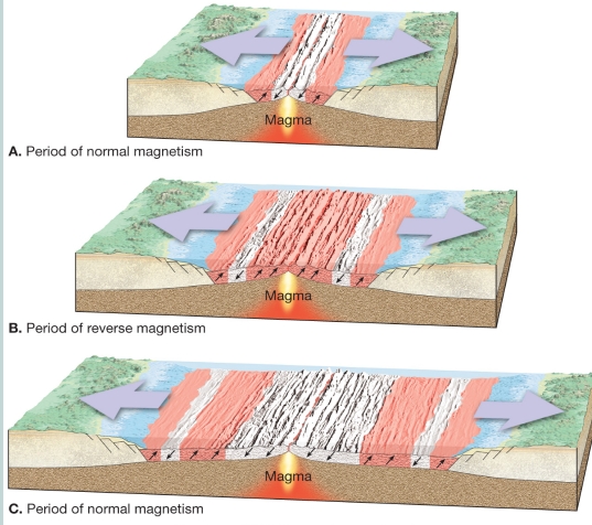
Geomagnetic reversals are recorded in the ocean crust
In 1963 Vine & Matthews tied the discovery of magnetic stripes in the ocean crust near ridges to Hess’s concept of seafloor spreading
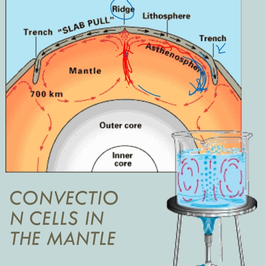
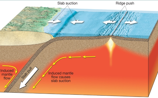
Forces that drive plate motion
Convective flow in the mantle
Slab pull
Ridge push
Slab suction
The End
