
Chapter 6 : Geology 101
Earthquakes
Vibration of Earth produced by the rapid release of energy
The movement of the ground, is caused by waves of energy released as rocks move along faults which means that earthquakes are associated with movements along faults
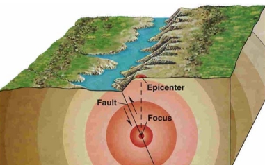
Fault a large fracture in rocks, from several m to Kms long, where rocks move along which displacement has occurred
Explained by the plate tectonics theory
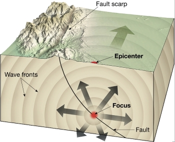
Epicenter the point on Earth’s surface directly above the focus
Elastic rebound theory
earthquakes occur as rock elastically returns to its original shape
Mechanism for earthquakes was first explained by H. Reid
Elastic Rebound Theory Rocks spring back into its original shape as stress removed
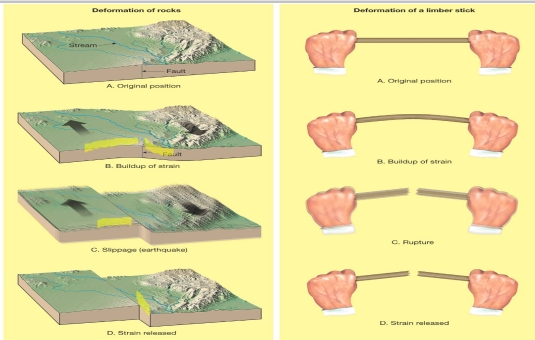

foreshocks & aftershocks
Earthquakes are often preceded by foreshocks & followed by aftershocks
Foreshocks indication, weak earthquakes, releas some of energy
Aftershocks followed the earthquakes, releas some of energy as crust return to its original shape (crust unstable)
Earthquake waves
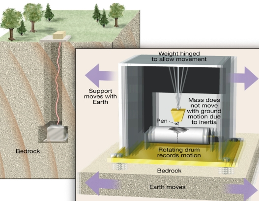
Seismology Study of earthquake waves
Seismograph Earthquake recording instrument, Records movement of Earth
Seismogram Record made by seismograph
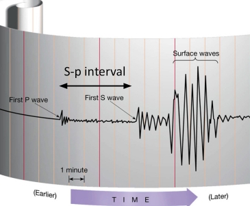
Types of earthquake waves
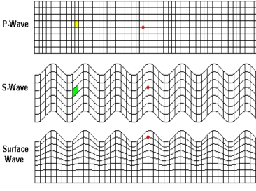
1. Body waves: Primary (P) & Secondary (S)
2. Surface waves


Types of earthquake waves
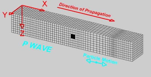
Body waves: Primary waves (P)
– Push-pull (compressional) motion
– compression & expansion
– First to be recorded at a seismograph
– Travel through solids, liquids, & gases
– Greatest velocity of all earthquake waves
– longitudinal wave: Causes rock to vibrate in the same direction the wave is traveling
Body waves: Secondary waves (S)
– Shake or transverse (shearing) waves
– causes the rock to vibrate at right angles to the direction of travel (to the direction of propagation)
– Travel only through solids
– Slower velocity than P waves
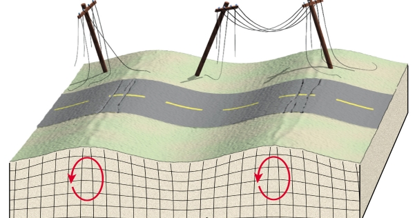
Surface waves
– Complex motion
– Slowest velocity of all waves
– The largest & most destructive
– like ocean waves

Locating an earthquake
Earthquake zones are closely correlated with plate boundaries
1. Circum-Pacific belt
2. Oceanic ridge system
When analysing an earthquake the first task seismologists undertake is determining its epicenter
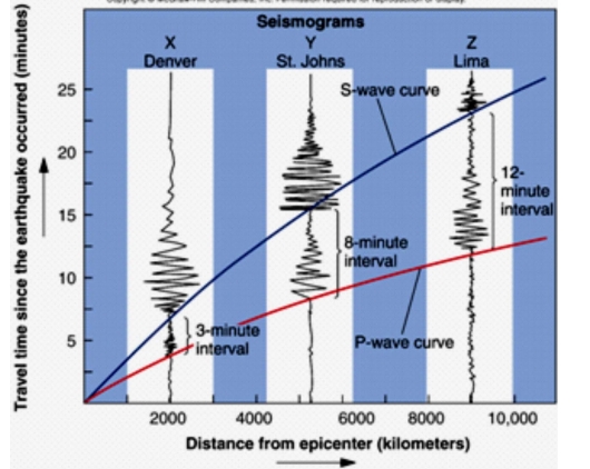
1. The difference in arrival times of P & S wave are determined from the seismogram
2. Using travel time graphs find the (S-P) interval on the vertical axis to determine the distance on the horizontal axis
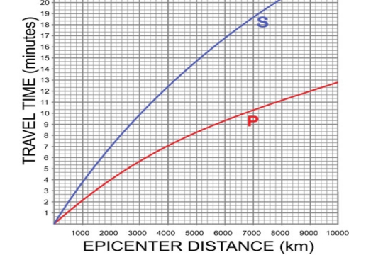

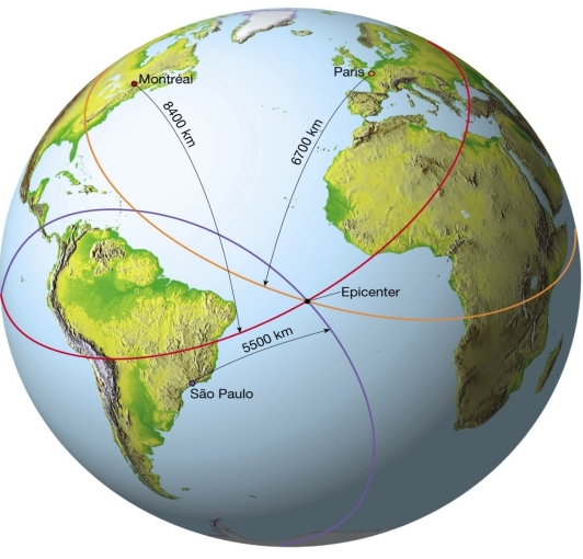
Circle equal to the epicenter distance is drawn around each station
epicenter is at Point where 3 circles intersect
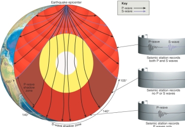
Principle for study Earth’s interior
Most of our knowledge of Earth’s interior comes from the study of P & S waves
Travel times of P & S waves via Earth depend on properties of materials
Velocity of waves increases with depth.
Seismic waves are refracted as they pass through the earth
Waves follow strongly curved paths
S waves travel only through solids
Earthquake intensity and magnitude
Intensity A measure of the degree of earthquake shaking at a given locale based on the amount of damage
– measured by the Mercalli Scale
Magnitude amount of energy released
– Concept introduced by C.Richter
– Measured using the Richter scale or Moment Magnitude scale
Magnitude Scales
Richter scale
– Based on amplitude of largest wave
– logarithmic scale: 1°→1, 2°→10, 3°→100
– Each unit = to 32-fold energy increase
– Doesn’t useful for large earthquake (>7)
Moment magnitude scale
– Measures very large earthquakes
– Derived from the amount of displacement that occurs along a fault zone
< 2 → Micro
2 – 3.9 → Minor
4 – 4.9 → Light
5 – 5.9 →Moderate
6 – 6.9 → Strong
7 – 7.9 → Major
8 – 9 → Great
Earthquake destruction
Factors that determine structural damage
1. Intensity of the earthquake
2. Duration of the vibrations
3. The design of the structure
4. Nature of the material upon which the structure rests
Destruction results from
1. Ground shaking
2. Liquefaction of the ground
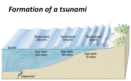
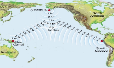
3. Tsunami, or seismic sea waves
4. Landslides & ground subsidence
5. Fires
Liquefaction caused by
1. Saturated material turns fluid
2. Underground objects float to surface
– during Liquefaction water-saturated soil behaves as a fluid. It becomes incapable of supporting much weight
– such as sandy soil
Earthquake prediction
Short-range prediction
– no reliable method yet devised
Long-range forecasts
– Premise is that earthquakes repetitive
– Region is given a probability of a quake
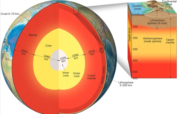
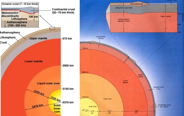
Earth’s Layers defined by composition
Crust Thin, rocky, & outer layer
Continental crust
– Upper crust composed of granitic rocks
– Lower crust is more akin to basalt
– Average density is about 2.7 g/cm³
– older than oceanic (Up to 4Ga)
– thickness 35-40 km
– thickness at some mountainous 70 km
Oceanic Crust
– Basaltic composition
– Density about 3.0 g/cm3
– Younger (<180Ma) than the continental
– thickness 7km
Mantle : Below crust to 2900Km depth
– Composition : of the uppermost is igneous peridotite & changes at greater depths
Core : A sphere having a radius of 3486 km
Location Below mantle
– Composition : iron-nickel alloy
– density ≈ 11 g/cm3
Earth’s Layers defined by physical properties
Lithosphere Crust & Uppermost mantle
– 100km thick
– Cool, rigid, & solid
Asthenosphere Beneath the lithosphere
– Upper mantle
– To a depth of about 660Km
– Soft, weak layer that is easily deformed
Mesosphere lower mantle
– 660-2900 km
– More rigid layer
– Rocks are hot & capable of gradual flow
Outer core Liquid layer
– 2270 km thick
– Convective flow of metallic iron within generates Earth’s magnetic field
Inner Core Sphere with a radius of 1216km
– Behaves like a solid
Rock Deformation
Deformation general term refers to changes in the original shape & size of a rock body
Most crustal deformation occurs along plate margins
Rocks deform permanently in 2 ways:
1. brittle deformation
2. ductile deformation
Brittle deformation is the fracturing of an object once its strength is exceeded
Ductile deformation type of solid state flow that produces a change in the size & shape of an object without fracturing the object
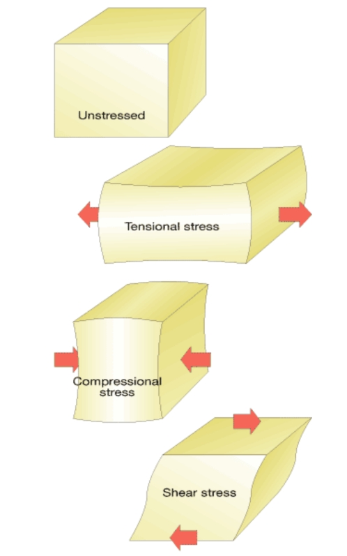
Stress
Stress is the force/unit area acting on a solid
Strain is the change in shape or volume of a body of rock as a result of stress
Types of Stress
1. Tensional stress
2. Compressional stress
3. Shear stress
Geologic Structures
Anticlines Fold upfolding or arching of strata
Synclines Fold downfolds in strata
– found in association with anticlines
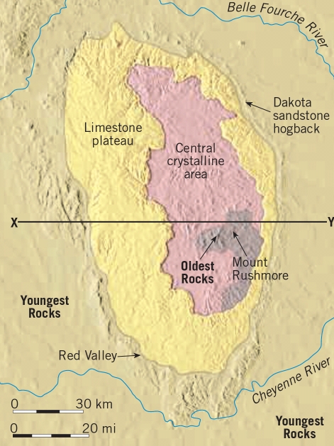
Domes circular or elongated structure, produces by upwarping of the crust
– Older rocks are exposed in the center
– the youngest rocks exposed in the flanks
Basin circular or elongated structure, produces by upwarping of the crust
– youngest rocks are exposed near the center
– the oldest rocks exposed near the flanks
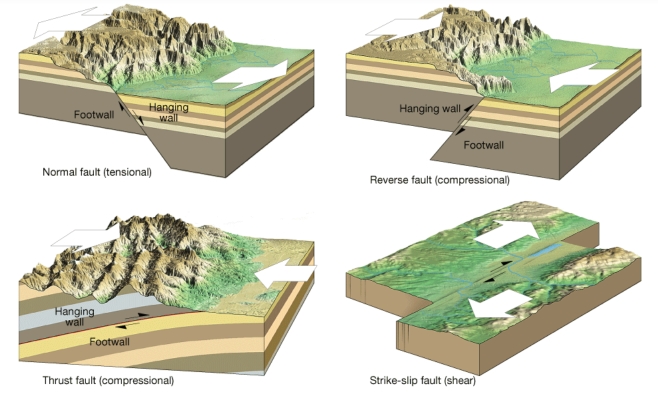
Faults: are fractures in the crust along which displacement has taken place
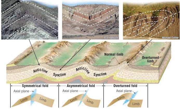
Symmetrical Fold : if dip angle of 2 limbs equal each other
Asymmetrical Fold : if dip angle aren’t equal
Overturned Fold : the 2 limbs dipping in tha same direction
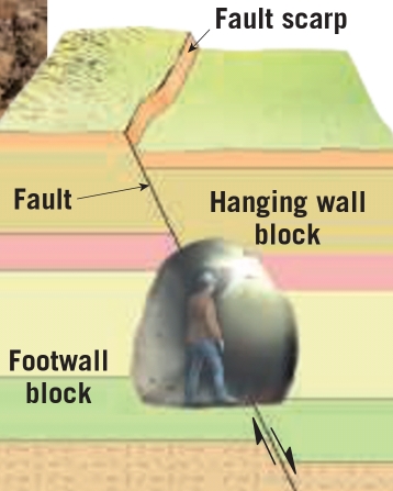
Faults
Dip- slip Faults: movement parallel to dip
1. Normal fault: occur if the hanging wall block moves down relative to the footwall
2. Reverse fault: hanging wall block moves up relative to the footwall block
3. Thrust fault: reverse with dips < 40°
Strike-slip faults are faults in which the movement is horizontal & parallel to the trend, or strike, of the fault surface
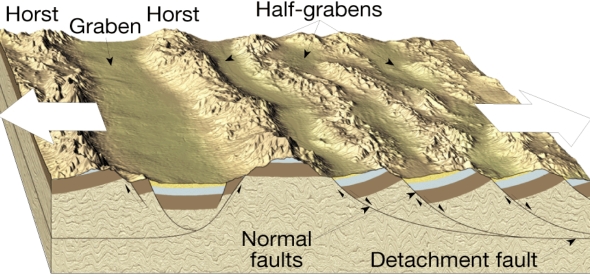
fault-block mountains
formed as large blocks of crust are uplifted & tilted along normal faults
Grabens formed by downward displacement of fault-bounded blocks
Horsts are elongated, uplifted blocks of crust bounded by faults
Mountain Building
Folded Mountains formed by compressional forces
Orogenesis result in forming of mountains
Young mountain belts (less than 100Ma):
1. American Cordillera
2. Alpine-Himalaya chain
3. volcanic island arcs (Philippines, Japan)
Older mountain belts
1. Appalachians in N-America
2. Ural Between Europe & Asia
Occurrence
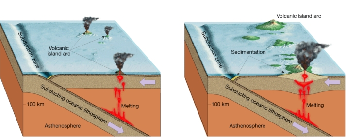
Most mountain building occurs at convergent plate boundaries
Colliding plates provide the compressional forces that fold, fault, & metamorphose the thick layers of sediments deposited at the edges of landmasses
Ocean-Ocean Convergence produces volcanic mountains (volcanic islands arc)
Ocean-Continental Convergence volcanic mountains & folded mountains
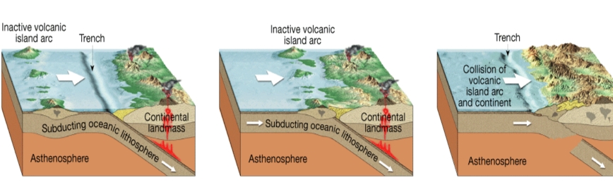
Accretion process that occurs when crustal fragments collide with & stay connected to a continental plate
Accretionary wedge is the accumulation of different sedimentary & metamorphic rocks with some scraps of ocean crust
Terranes any fragments that have a geologic history distinct from that of the adjoining fragments
– Terranes occur along the Pacific Coast
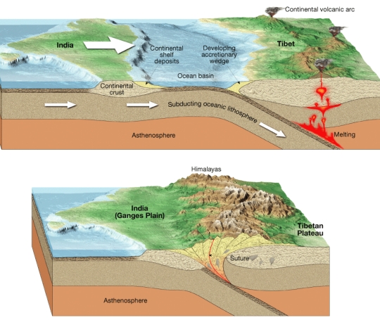
At a convergent boundary a collision between the continental fragments will result & form folded mountains
The End
