
Thunderstorms
Thunderstorm
Storm that generates lightning & thunder
Characterized by strong up & down motion
Produces gusty winds, heavy rain & hail
They can form in
1. conjunction with mid-latitude cycloneon the edge of a Cold-Front
2. conjunction with hurricanes
Occur in the foothills of the Rocky Mountains
Associated with drylines, different humidity
Thunderstorm Formation
Form when warm, & humid air rises in a conditionally unstable or unstable env.
There are 2 categories:
1. Air Mass Thunderstorms: formed by unequal heating of the Earth’s surface within a maritime tropical (mT) air mass
2. Severe Thunderstorms formed by unequal heating & lifting of warm air along a frontor mountain
Air Mass Thunderstorms
Happens inside an air mass (mT)
Usually in spring & summer, mid-afternoon
Not associated with a front
Due to local differences in T
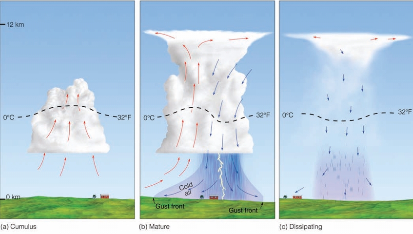
Thunderstorm Life Cycle
Like mid-latitude cyclones, T-Storms have a Life Cycle
Stages of Development
Stage 1: Cumulus Stage
Stage 2: Mature Stage
Stage 3: Dissipating Stage
The Cumulus Stage
– Rising air only, Makes a bigger cloud
– Moisture is being added to higher altitudes
– Needs a continuous supply of moisture
The Mature Stage
– Precipitation, by the Bergeron Process
– Rain begins to fall, downdraft
– Updrafts & downdrafts exist side by side
– Most active stage: winds, lightning, rain, hail
Dissipating Stage
– Cooling effect of falling precipitation
– influx of colder air up topmark it’s END
– Downdraft cuts off updraft
– Cloud stops growing
– You’re left with weakly descending parcels
– The cloud basically KILLS itself
downdraft (air going down)
form for two reasons
Entrainment: mixing of dry air with cloud air at the edge of the cloud
– Causes the cloud drops to evaporate
– Energy comes from the T of the air parcel
– Temperature drops, parcel cools
– Cooler air sinks to the surface
Drag: Air dragged downwards as precipitation falls
Severe Thunderstorms
Heavy downpours, flooding, gusty straight-line winds, large hail, lightning & tornadoes!
– NOT Common on Hawaii & Pacific Islands
To be classified as Severe:
Must have winds in excess of 93 km/h
hail 0.75 inches
a confirmed tornado
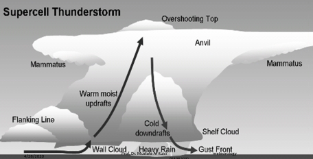
Persist for many hours Vertical wind sheer causes precipitation to fall in downdraft, allowing the updraft to retain strength
– Sometimes the updraft is so strong you get overshooting tops & anvils
Cold air of the downdrafts making: mini cold front (GUST FRONT or Outflow Boundary)
Can form a Roll Cloud

Supercell Thunderstorm
Causes dangerous weather
Large, very powerful, up to 20 km in height
Last many hours
20-50 km in diameter
Vertical wind profile may cause the updraft to ROTATE!
MESOCYCLONE usually spawns Tornadoes
Need a lot of Latent Heat
– Requires moist troposphere
– An inversion a couple of km above the surface (caps moisture)
– Unstable air can break through the inversion by “eroding” it
Lightning and Thunder
Lightning is uliain Hawaiian
Thunder is hekiliin Hawaiian
A storm is classified as a thunderstorm only after thunderis heard,
Because thunder is produced by lightning
Lightning is a discharge of electrical energy
Essentially a giant “spark” between regions of positive (+) & negative (-) charge
Lightning
Occur Between
1. cells in same storm: inter-cloud lightning
2. Within a cloud: intra-cloud lightning
3. Cloud to air
4. Cloud to ground (CG)
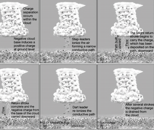
Forms if a charge separation occurs in cloud
1. Earth trying to equalize electrical difference
2. – ve charges want to flow to the ground
Lightning Formation (Charge Separation)
We don’t exactly know why it happens
One theory:
– Hail stonestend to have a warmer surface than ice crystals
– When warm hail collides with colder ice, electrons transfer from ice to hail
– Hail (-) is bigger & heavier & settles toward the bottom of the cloud
– Smaller (+) ice crystals are lofted to the top
Excess electrons cause the air to ionize: Rip molecules apart (N₂ or O₂ become N+, O-)
– Air is normally very INSULATING
– Ionized air is very conducting
– like a metal
– Ionized air forms tubes of 50 m in length & 10 cm in diameter (LEADER)
– A bunch of leaders that are connected is called a STEP-LEADER.
– NOTE: There still hasn’t been a flash yet!!!
Each electron contains LOTS of energy
When it reaches the surface the energy is RELEASED as HEAT, Electrons are drained at the surface first so the FLASH starts at the ground, Can have several (3-4) in rapid succession (1/10 of a second apart)
(lead by a DART LEADER)
– This is why lightning is said to GO UP, rather than down
The movement is STILL from CLOUD to GROUND–But the “heating” happens at the surface FIRST.
The electrons closest to Earth are “discharged” first
Heatthat is released causes air around a step-leader to reach 30,000°C (54,000°F)
The warmer, the shorter the shorter the wavelength
Thunder
When air is heated quickly a shockwave forms & causes thunder
Similar to planes crossing the sound barrier, firecrackers & gun shots
Sound travels at 330 m/s or 1000ft/s
If thunder takes 3 seconds to happen after observing lightning then the storm is:–3 s * 1000 ft/s = 3000 ftaway (6/10 of a mile away).
The End
