Oline Quiz parts 1 & 2

Online Quiz part 3
Mountain Building & Drifting Continents
Part.1: Mountains Building
The origin of continents Theories
The birth of the moon: The Pacific ocean is a scar from which the moon was torn
Catastrophic events: continental crust broken & redistributed by Catastrophic events
The expanding theory: the earth was expanded to double its original size, & the ocean basins formed as cracks between the ruptured continents
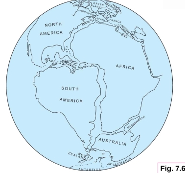
Continental drift: Parallelism of outlines of the opposing coasts of the S-Atlantic was observed & In 1859, the first map fitting S-America against Africa was published → the concept of large-scale rearrangement of continents, or Continental drift
A geosyncline
elongate belt of thick strata that linked closely with the formation of mountains
It shows tightly compressed folds
low angle overthrust faults
Most contain granitic batholiths & regionally metamorphosed rocks
Developed within structurally unstable orogenic belts located between stable regions, such as:
– Modern oceanic island arc-trenches
– Volcanic arcs, especially in midoceans
The Geosynclinal Concept
Hall’s Theory
1. Thick sedimentation along the edge of the continent depressed the crust as deposition occurred
2. Down bending crust stretched & faulted
3. Overlying sediments compressed & folded
4. Last result that a topographic mountains were raised at the surface
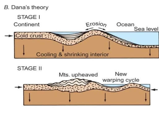
Dana’s theory
1. Bending of crust as the interior cooled & shrinkage
2. Bending was concentrated at continental margins where erosion of upraised genaticline provided sediment to an adjacent geosyncline
3. Finally, crust failed, mountains raised, & the geosyncline was welded to the continent
Repetition of this process caused growth of the continent through mountain building
Until now, mountain belts are primarily the results of profound (deep) lateral compression across relatively narrow zones

type of forces required to Mountain Building
1. A cooling & Shrinkage of Earth
2. Continental Drift
3. Thermal Convection
A cooling & Shrinkage Earth
proposed by Dana
The earth cooling from a molten origin, so
1. The earth must be contracting
2. cold, & rigid crust must be bend or ruptur as interior shrinks
The most of the compressive adjustment of the crust would occur at the boundaries between continents & ocean basins, exactly where N-American mountains occur now
Thermal Convection
Proposed by A. Holmes
Mechanism: If more heat generated in one portion of deep mantel due to irregular distributions of isotopes
1. This material plastic flow upward, & cool
– ruptured the crust
2. then flow laterally beneath the lithosphere
– drag the crust along conveyor belt fashion
3. as it cool the mantle below, it sink (move downward)
– buckle up to form mountains

1. convection begins to stretch an overlying continental block
2. block ruptures & 2 fragments move apart
Continental Drift
Taylor suggested that Drifting continents had caused wrinkling of the crust to produce Cenozoic mountain systems
mechanism:
1. The leading edges of the moving continents depressed the oceanic crust a head to form troughs in which sediments could accumulate
2. Further movement then compressed & up-heaved those strata to produce the present mountains rimming the Pacific
The catastrophic tidal action as a force source was rejected
Up-heaval of the Alpine-Himalayan resulted by the direct collision of continents
Baker, speculated severe tidal distortion that a large portion of the continental crust was torn from the Pacific to form the moon, with the remaining continental crust rupturing & slipping toward the Pacific void (Place)
This source of force was rejected because:
1. No record in Cenozoic strata of a catastrophic of such magnitude.
2. The last major displacements of continents began in early Mesozoic time
Drifting apart of continents occurred over a long period during Mesozoic & Cenozoic Eras
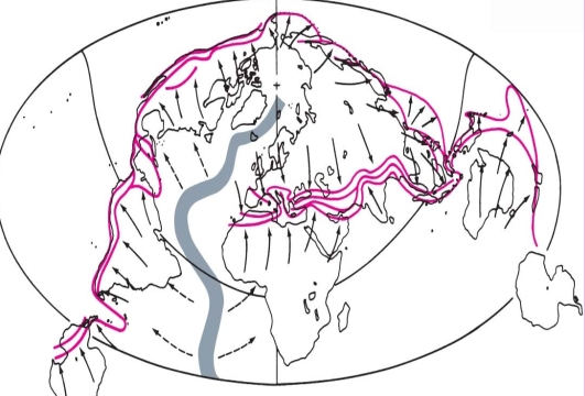
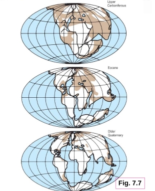
He was the first who attempted to reconstructed the former supper continent by fitting edges of continental shelves rather than present coastlines
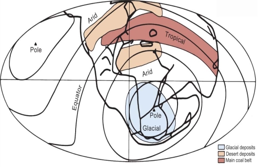
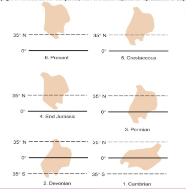
Wagener appealed to apparent paleoclimatic indicators in late Paleozoic rocks, including glacial, desert, & tropical rain forest deposits, to reconstruct Permian climatic zones
Du Toit support Wegener with many fossils, found now in widely separated continents
Wegner reconstruct the Permian continents & Paleo-climate zones
Part.2 : Paleomagnetism
Paleomagnetism-Drift’s Renaissance
Young lavas should show magnetization parallel to that of the earth’s present field
The magnetic minerals retain their fossil, or magnetism unless heated above the demagnetization temperature (500ºC)
many rocks, containe these minerals today retain evidence of orientation of magnetic field when & where they were formed

The inclination θ is relative to the horizontal surface provides evidence for paleo-latitude
-Steep inclination→formation at high latitude
– very low θ indicates location near equator
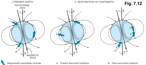
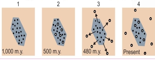
Present earth showing magnetically susceptible mineral orientations in modern rocks on 3 continents
The positions of fossil magnets in rocks of the same age on each continent, Each discordant with the field at its present position
Their pre-drift positions found by rotating each to a paleolatitude that is concordant with the magnetic field continent Y & Z may have been part of single super continent before they drifted to their present positions
the progressive counterclockwise rotation & northward shift through time
Part.3 : Sea Floor
General Nature of the Sea Floor
Before 1960s, geologists assumed that the crust beneath ocean basins was:
1. very old
2. topographically feature less
3. structurally tranquil
4. essentially fixed in place
– All assumptions appear to be incorrect
Profiles established by reflection of low-frequency waves from shown that:
1. Ocean floor not smooth & characterized by ridges, deep trenches, & sea mountains
2. rugged & younger than continental crust
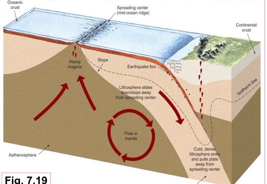
Oceanic Ridges
Oceanic ridges: zones of extension along which the crust is being to torn open
– scars of a pre-drift configuration of crust
– made mainly of basaltic lavas
– Show a high volcanic activity
– display shallow seismicity beneath axes
– characterized by greater than average heat flow through the crust along their axes
– had a narrow depressions that extends along their axis for thousands of kilometers
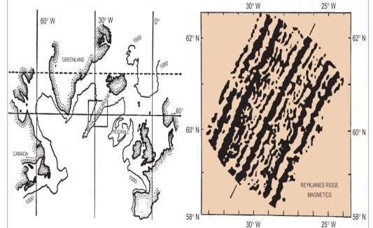
Submarine ridges: The most striking features of ocean floor (Atlantic & Indian)
Rift: any branch in ridge (Ridge patterns may be complicated by branching)
Triple Junction: juncture of 3 separate rifts
part of Carlsberg Ridge of the Indian Ocean
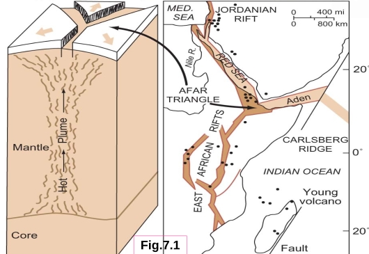
Afar Triangle is a triple-junction intersection of Red Sea, Aden, & east African rifts
It is probably the surface expression of a hot mantle plume
Such a system of diverging rifts initiates new continental drifting episodes
Dots indicate young volcanoes
sea-floor spreading hypothesis
Proposed by Hess
2 opposing convection cells rising beneath ocean ridges cause the abnormal heat flow & produce tension in crust
convective flow laterally away from ridge axes causing the spreading of sea floors
Examples/application for Hess hypothesis:
1. Atlantic & Indian Oceans
2. E-Africa & Arabia experiencing the beginning of new phase of disruption in response to the shift of mantle convection
3. Spreading along the extension of W-Indian Ocean tore open the Aden rift in crust
Mechanism by which rising hot mantle plumes drive rifting & continental drifting
1. Continents situated over mantle (hot spot)
2. Uplift or flat continental plate form triple junction with 3 cracks, & igneous dikes
3. As 3 cracks get wider, 2 arms open up to form ocean basin & third (failed) arm becomes sediment-filled trough (Aulacogen)
Aulacogen is a trough formed by a rift that has failed to develop
– Ex. southward-trending East African rift
E-African rifts are tectonically active, they have not opened up as has Red Sea-Aden system, because They have continental crust beneath rather than oceanic
The Aulacogens have a special important
1. Many great rivers flow down it
2. Important petroleum resources
3. Ore deposits formed where hot solutions rise along the faults bordering the troughs
Confirmation of Sea-Floor spreading
Wilson proposed that oceanic islands symmetrically distributed as to relative age outward from ridges: youngest islands near the axes of ridges, & oldest away
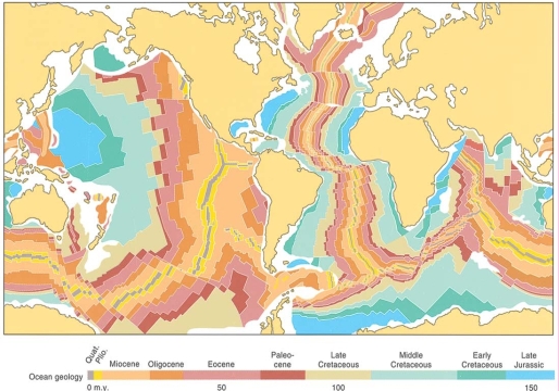
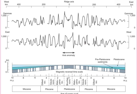
Sea-floor Spreading was confirmed by magnetic Anomalies
anomalies strips show 2 striking features
1. Parallel closely the ridge axis
2. Have bilateral symmetry (mirror plane)
anomalies reflect successive reversal of polarity of the magnetic field while the sea floor was spreading away from the ridges
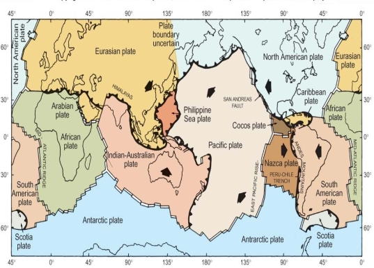
Arrows summarize directions of plate motion, which confirm the hypothesis of sea-floor spreading by showing:
1. divergence or extension from ocean ridges
2. convergence or compression at volcanic arc-trench (subduction) zones
Plate Collisions
Erosion able to reduce continents to sea level in a mere 10Ma, the persistence of continents requires some rejuvenation mechanism
Isostasy equilibrium among the larger units of the crust according to their total mass
1. thinner, denser units (ocean) stand lower
2. thicker, less dense (continents, mountains) stand higher
Crust sink if load of sediment or ice added
Crust rise if rock were removed by erosion
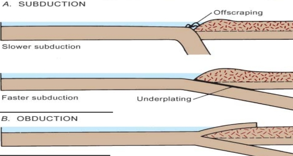
Faster subduction → law angle
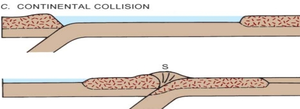
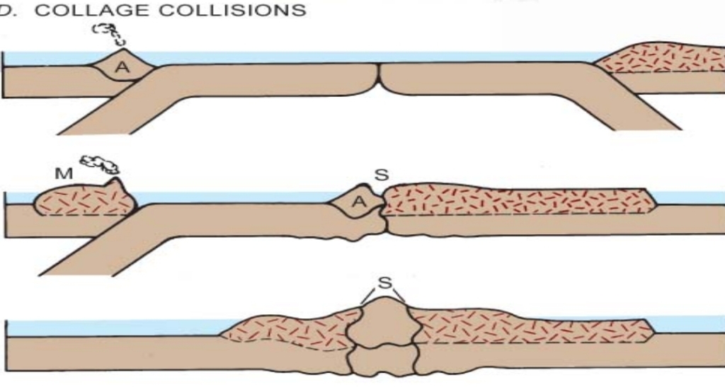
B. Obduction of overthrusting of slab of oceanic over continental crust
Symbols Used
S: collision suture
A: volcanic arc
M: microcontinent
Sedimentary basins
Areas of thick sediments vary in:
1. size
2. shape
3. tectonic setting
Sedimentary basins include
1. trench, forearc, & foreland
3. intracratonic, & passive margin
4. rift or aulacogen basins
Accumulation of thick sediments require one or both of the following
1. sea level rose
2. underlying lithosphere subsided during deposition
The sea level variation can not explain the presence of thick sediments, so they are indirectly related to plate tectonics
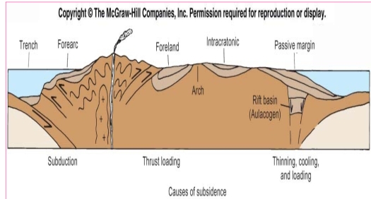
Causes of Subsidence
1. Subduction subsidance
2. Thermal or cooling subsidence
3. Crustal-thinning subsidence
4. Sediment-loading subsidence
5. Thrust loading
Subduction subsidance: caused by the profound forcible depression of one lithosphere plate as it is subducted beneath another
Thermal or cooling subsidence: caused by the cooling of a lithosphere plate as it moves away from a hot, spreading ridge
Crustal-thinning subsidence: can provide space for thick sediment accumulation as a result of isostatic subsidence of any crust that has been thinned
Sediment-loading subsidence: This type of loading is limited by the initial depth of water & ratio of densities of the loading material & of the crust & mantle beneath
Thrust loading: occurs when a collision of 2 lithosphere plates happened, so over- thrusting of thick slabs of rock onto the edge of a craton formed.
Thick sediment can accumulate in the foreland sedimentary basin formed by the resulting isostatic subsidence