
Online Quizzes

1st : Haze & Foge

2nd : Clouds
Condensation
Haze & Fog
Haze
layer of dust or salt particles suspended above the region
tiny dry haze particles scatter some rays of sunlight, & allowing others to penetrate air.
The scattering effect of dry haze
1. bluish color when viewed against a dark- colored background
2. yellowish when viewed against a light- colored background
As the air cools during the night, the RH increases, & When the RH = 75٪, condensation may begin on the most active hygroscopic nuclei, producing a wet haze
FOG
cloud with its base at or near the ground
Types of Fog:
Fogs formed by Cooling
1. Radiation
2. Advection
3. Upslope
Fogs formed by Evaporation
1. Steam
2. Frontal
Radiation Fog
Fog formed During the night, when The ground cools the air close to the surface
– Tend to form on clear, relative calm night when cool, moist air is overlain by drier air & rapid Radiational Cooling occurs
– Clear Skies
– Fairly high RH
– Cold air sinks in valleys
– Dissipate يبدد after sunrise

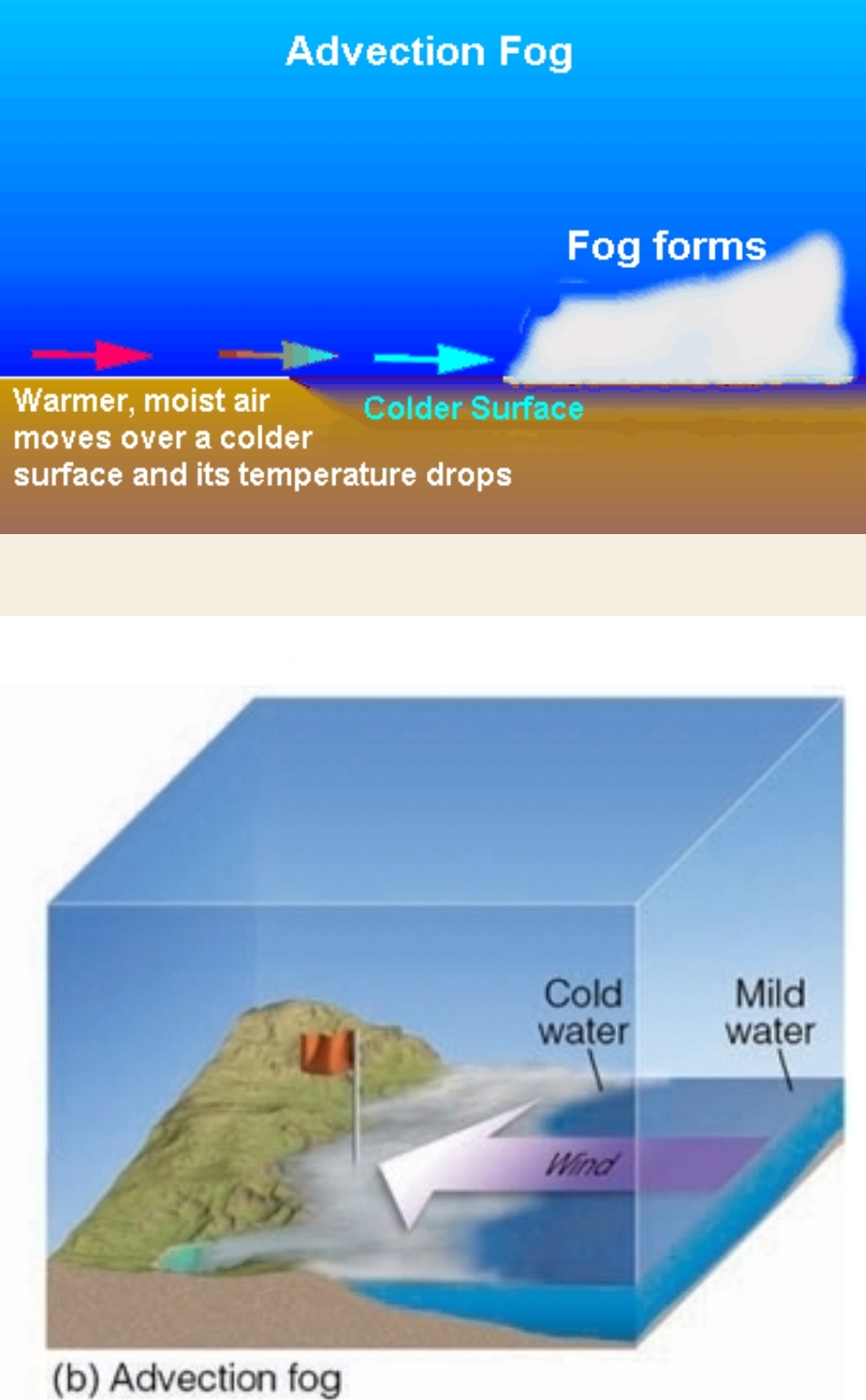
Advection Fog
Fog formed by horizontal movement of air, if Warm moist air is blown over a cold surface
– Advection = horizontal movement
– Turbulence (wind) is needed to make it thick
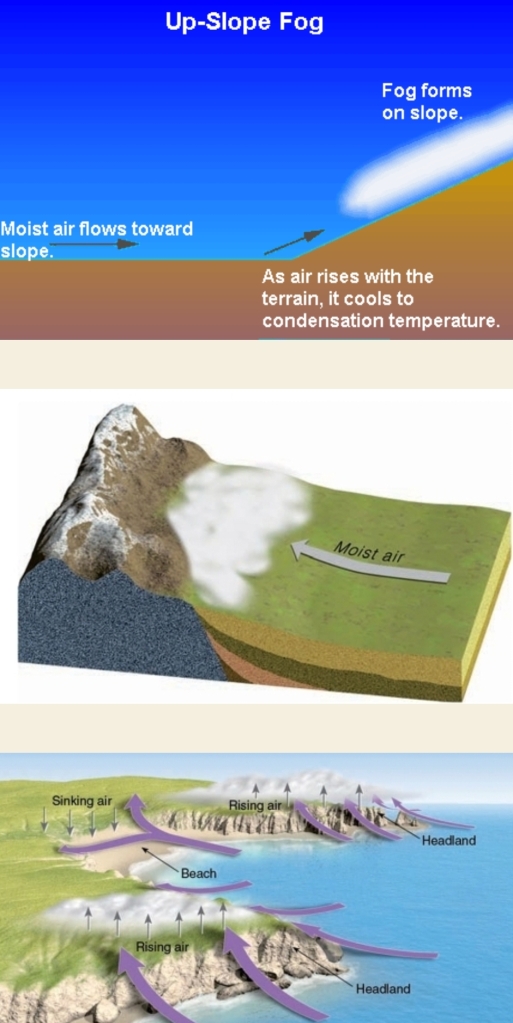
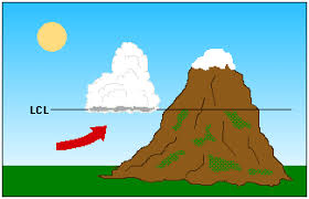
Upslope Fog
Fog formed as humid air moves up a gradual sloping plain or mountain (or as Moist air rises, cools, & condenses over elevated terrain)
– it cools as moves up, formed at dew point
– Most likely to form along an Irregular Coastline at the headland
– headland: region of land extended seaward
– Ex: Great Plains
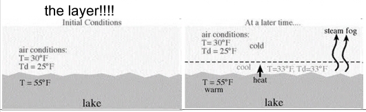
Steam Fog
Fog formed as Cool air moves over warm water
– Rising air cools & condenses
– Moister added into the layer

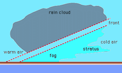
Frontal Fog
as warm air is pushed over a colder one
– If cold air is near dew, point rain evaporate & produce fog
– Results addition of H₂O(g) into cool air layer
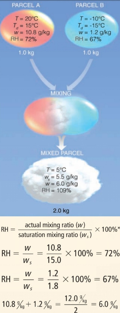
Fog That Forms by Mixing
clouds
cloud
any visible aggregate of tiny droplets of water or ice crystals, or mixture of both
Cloud drops, on average 10 um in diameter
Come in a variety of shapes & sizes
Found at a large range of altitudes from the surface to the stratosphere
Help meteorologists figure out what’s going on in the atmosphere
Recipe for a Cloud
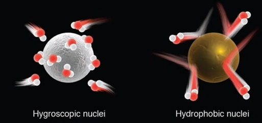
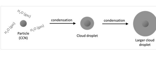
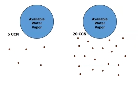
1. Cloud Condensation Nuclei (CCN): the surface for water vapor to condense upon
2. Rising Air: Causes adiabatic cooling
3. Water Vapor
Why do you need CCN?
Without CCN the RH would have to be much greater than 100% to form a cloud drop
hygroscopic particles is water-seeking or liking, vapor rapidly condenses on their surfaces, such as Sea salt
Hydrophobic Particles water repelling, resist condensation, can still serve as nuclei when RH is > 100%
Why are cloud drops so TINY?!
The drops grow FAST & other aerosol want water too
H₂O is split up over a lot of little dropsinstead of a few big ones

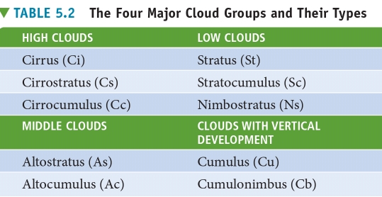
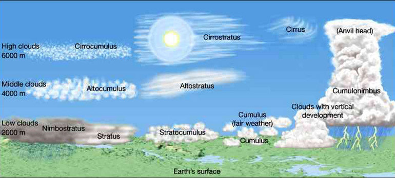
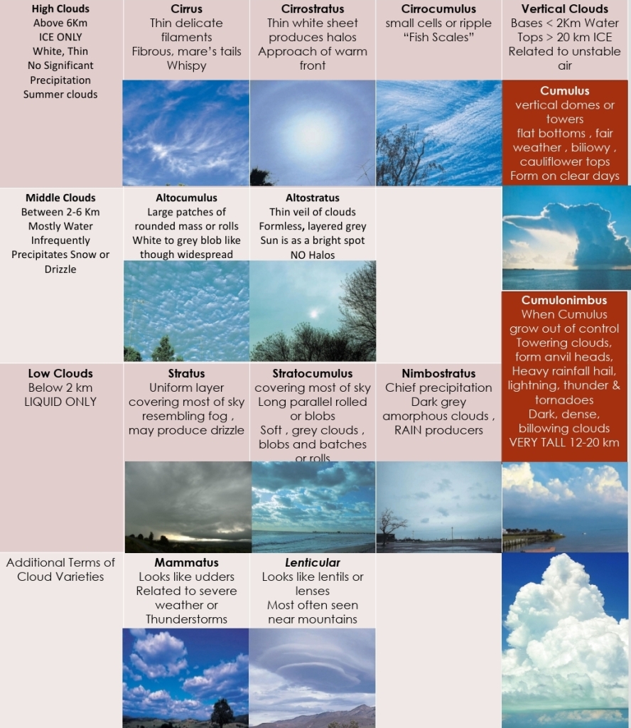
Cloud Classification
History & Classification System
Ancient astronomers named the major stellar constellations about 2000 years ago
Lamarck proposed the first system for classifying clouds in 1802
One year later, L.Howard, developed a cloud classification system that found general acceptance
Howard’s system used Latin ‘“words” to describe clouds as they appear to a ground observer
1. sheet-like cloud = stratus = layer
2. puffy cloud = cumulus = heap
3. wispy cloud = cirrus = curl of hair
4. rain cloud = nimbus = violent rain
These system has 4 basic cloud forms, & Other clouds described by combining basic types.
nimbostratus : rain cloud, shows layering
cumulonimbus : rain cloud having pronounced vertical development (puffy)
Then, Abercromby & brandsson published a classification system that is still in use today
Abercromby-brandsson system
include:
– 10 principal cloud forms
– 4 primary cloud groups
Each group identified by:
1. the height of the cloud base
2. their appearance
Groups
1. high clouds
2. middle clouds
3. low clouds
4. vertical clouds
The End
